UTILITIES LOCATING & MAPPING
Utility Scanning & Locating Engineering using Cutting Edge Technology Scanning
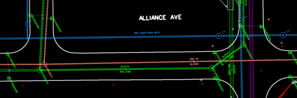
Utility line locating is the process of identifying and labeling underground utilities, which includes a multitude of subsurface services such as communications, electrical, gas, sewer, water, and any buried objects/lines. Utility line locating is essential for updating and confirming the accuracy of existing drawings and plans, which may be outdated. According to contracting laws, any planned ground disturbance must be notified to utility providers through the Ontario One Call platform. This platform accumulates all available ‘current’ information on subsurface pipe, cable, and duct installations. However, this information is not always complete or accurate enough to ensure safe excavation. Results from utility locator surveys are detailed in an informative work order, including a 2D PDF sketch with subsequent information on each utility present.
Advanced Locates offers a comprehensive service package that includes:
- General Locate Package: A 2D PDF sketch and a detailed work order.
- Subsurface Utility Engineering (SUE) Report: Compliant with CI/ASCE 38-22 standards, this report includes GPS/Total Station data points for the location and depth of confirmed underground and surface utility features, including unknowns and suspected abandoned lines. These data points are incorporated into an engineering drawing using CAD software and accompanied by a concise survey report.
UTILITY SCANINNG & LOCATING Engineering USING Advanced tech Subsurface Utility Engineering
Benefits of SUE
Subsurface Utility Engineering (SUE) is a key aspect of the pre-design engineering phase for projected developments. It is a useful method for maintaining up-to-date records of privatized facilities. The produced CAD files can be used to design and plan the implementation of future utilities before any proposed ground disturbance, ensuring safety and efficiency in project execution.
- Subsurface Utility Engineering (SUE) Create Accurate As-Built Drawings of Underground Infrastructure
Subsurface Utility Engineering (SUE) is critical for creating precise as-built drawings of underground infrastructure. By utilizing advanced techniques and technology, we provide accurate and reliable data essential for the pre-design engineering phase of developments.
- Utility Line Locating
Utility line locating involves identifying and labeling underground utilities, including communications, electrical, gas, sewer, water, and more. This process is vital for updating and confirming the accuracy of existing drawings and plans, ensuring safe and efficient excavation and construction activities.
- GIS Utility Mapping
Using cutting-edge GIS technology, we create comprehensive base maps for small cities and municipalities. These maps help municipal planners and civil engineers effectively plan and manage underground utility systems. They are essential for efficient repairs, replacements, and future infrastructure development.